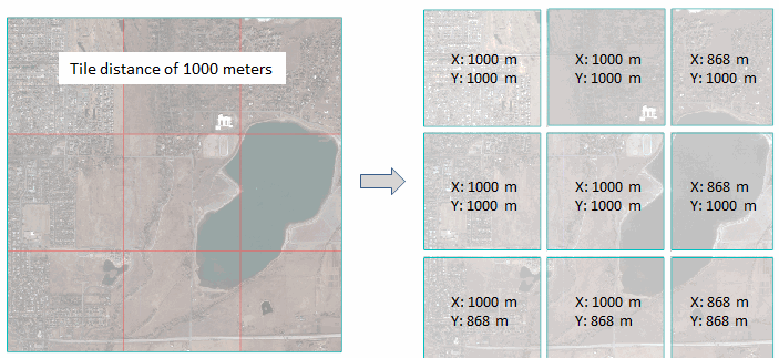
This task separates a raster into tiles based on a specified distance. In most cases the tiles in the last row and column will be smaller than the specified distance, as the following example shows:
Example
e = ENVI()
File = Filepath('qb_boulder_msi', Subdir=['data'], $
Root_Dir=e.Root_Dir)
Raster = e.OpenRaster(File)
Task = ENVITask('DiceRasterByDistance')
Task.INPUT_RASTER = Raster
Task.TILE_DISTANCE = 1000.
Task.DISTANCE_UNITS = 'Meters'
Task.TILE_GRID_VECTORS = 'true'
Task.OUTPUT_DIRECTORY = Filepath('', /TMP)
Task.Execute
DataColl = e.Data
DataColl.Add, Task.OUTPUT_RASTER
View1 = e.GetView()
FOR i=0,N_Elements(Task.Output_Raster)-1 DO $
Layer = View1.CreateLayer(Task.OUTPUT_RASTER[i])
vectorLayer = View1.CreateLayer(Task.OUTPUT_VECTOR)
View1.Zoom, /FULL_EXTENT
Syntax
Result = ENVITask('DiceRasterByDistance')
Input parameters (Set, Get): DISTANCE_UNITS, INPUT_RASTER, OUTPUT_DIRECTORY, TILE_DISTANCE, TILE_GRID_VECTORS
Output parameters (Get only): OUTPUT_RASTER, OUTPUT_VECTOR
Parameters marked as "Set" are those that you can set to specific values. You can also retrieve their current values any time. Parameters marked as "Get" are those whose values you can retrieve but not set.
Input Parameters
DISTANCE_UNITS (required)
Specify a string indicating the units of the tile distance. The options are:
- Meters
- Km
- Feet
- US Survey Feet
- Yards
- Miles
- Nautical Miles
INPUT_RASTER (required)
Specify the input raster. It must have an ENVIStandardRasterSpatialRef, ENVIRPCRasterSpatialRef, or ENVIPseudoRasterSpatialRef spatial reference defined.
OUTPUT_DIRECTORY (optional)
Specify the output directory for the tiles. If set to an asterisk (*), the output rasters will be virtual. This will not be written to disk, and the directory will not be created. If you do not set this parameter, the tiles will save to the directory indicated by the ENVI Output Directory preference.
TILE_DISTANCE (required)
Specify a double-precision value indicating the distance by which tiles are created, in the units specified by DISTANCE_UNITS. This value applies to both the X and Y direction.
TILE_GRID_VECTORS (optional)
Set this parameter to true to create an output shapefile that shows the tile boundaries.
Output Parameters
OUTPUT_RASTER
This parameter contains an array of output rasters. Their filenames contain the root name of the input raster with the row/column index appended in the form of RxCx. For example, R2C3 means row 2 and column 3.
OUTPUT_VECTOR
This parameter contains the output shapefile if you set the TILE_GRID_VECTORS parameter to true.
Methods
Execute
Parameter
ParameterNames
Properties
DESCRIPTION
DISPLAY_NAME
NAME
REVISION
TAGS
Version History
|
ENVI 5.4 |
Introduced |
|
ENVI 5.5 |
OUTPUT_DIRECTORY now supports '*', which allows OUTPUT_RASTER to be virtual output.
|
See Also
ENVITask, ENVITask::Parameter, ENVISubsetRaster, CreateSubrectsFromDistance Task, CreateSubrectsFromPixels Task, CreateSubrectsFromTileCount Task, CreateSubrectsFromVector Task, DiceRasterByPixel Task, DiceRasterBySubrects Task, DiceRasterByTileCountTask, DiceRasterByVector Task, ExportRastersToDirectory Task