This task warps an input raster to align with the base raster using tie points.
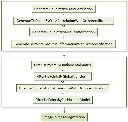
The following diagram shows where this task belongs within an image-to-image registration workflow:
References:
Jin, Xiaoying. ENVI automated image registration solutions. NV5 Geospatial Solutions, Inc. whitepaper (2017). ENVI automated image registration solutions can be downloaded from our website.
Jin, Xiaoying, and Robert Schafer. Method and system for automatic registration of images. Exelis, Inc., assignee; now owned by NV5 Global, Inc. U.S. Patent No. 9,245,201 (issued January 26, 2016).
Example
This example uses sample images from the Image Registration tutorial. The files are available from our ENVI Tutorials web page. Click the Image Registration link to download the .zip file to your machine, then unzip the files. Update the file references in the example with the correct locations.
e = ENVI()
File1 = 'quickbird_2.4m.dat'
File2 = 'ikonos_4.0m.dat'
Raster1 = e.OpenRaster(File1)
Raster2 = e.OpenRaster(File2)
Task = ENVITask('GenerateTiePointsByCrossCorrelation')
Task.INPUT_RASTER1 = Raster1
Task.INPUT_RASTER2 = Raster2
Task.Execute
TiePoints = Task.OUTPUT_TIEPOINTS
FilterTask = ENVITask('FilterTiePointsByGlobalTransform')
FilterTask.INPUT_TIEPOINTS = TiePoints
FilterTask.Execute
TiePoints2 = FilterTask.OUTPUT_TIEPOINTS
RegistrationTask = ENVITask('ImageToImageRegistration')
RegistrationTask.INPUT_TIEPOINTS = TiePoints2
RegistrationTask.WARPING = 'Triangulation'
RegistrationTask.Execute
WarpedRaster = RegistrationTask.OUTPUT_RASTER
DataColl = e.Data
DataColl.Add, WarpedRaster
View = e.GetView()
Layer1 = View.CreateLayer(Raster1)
Layer2 = View.CreateLayer(Raster2)
Layer3 = View.CreateLayer(WarpedRaster)
Syntax
Result = ENVITask('ImageToImageRegistration')
Input parameters (Set, Get): BASE_RASTER, DATA_IGNORE_VALUE, FULL_EXTENT, INPUT_RASTER, INPUT_TIEPOINTS, OUTPUT_PIXEL_SIZE, OUTPUT_RASTER_URI, POLYNOMIAL_DEGREE, RESAMPLING, WARPING
Output parameters (Get only): OUTPUT_RASTER
Parameters marked as "Set" are those that you can set to specific values. You can also retrieve their current values any time. Parameters marked as "Get" are those whose values you can retrieve but not set.
Input Parameters
BASE_RASTER (optional)
Set this parameter to one of the following strings, indicating which input raster is the base raster:
- Raster 1 from Tie Points (default)
- Raster 2 from Tie Points
DATA_IGNORE_VALUE (optional)
Specify a pixel value to fill areas where no image data appears in the warped image. The default value is 0.
FULL_EXTENT (optional)
Output the full extent of the warp image instead of the overlapping area only. The default value is 1 (true).
INPUT_RASTER (optional)
Specify the raster that will be registered to the base raster. This will take precedence over the warp raster defined in INPUT_TIEPOINTS.
INPUT_TIEPOINTS (required)
This is a reference to an ENVITiePointSet object.
OUTPUT_PIXEL_SIZE (optional)
Set the output pixel size in the map unit of the base raster. The default output pixel sizes are the same as those of the base raster.
OUTPUT_RASTER_URI (optional)
Specify a string with the fully qualified filename and path of the associated OUTPUT_RASTER.
- If you do not specify this parameter, or set it to an exclamation symbol (!), ENVI creates a temporary file.
- If you set it to the hash symbol (#), ENVI creates a file in the temporary directory, but this file will not be deleted when ENVI closes.
POLYNOMIAL_DEGREE (optional)
Specify the polynomial degree when using the Polynomial warping method. The default value is 1.
RESAMPLING (optional)
Specify the resampling method to use when creating the spatial grid:
- Nearest Neighbor (default): Uses the nearest pixel without any interpolation.
- Bilinear: Performs a linear interpolation using four pixels to resample.
- Cubic Convolution: Uses 16 pixels to approximate the sinc function using cubic polynomials to resample the image.
WARPING (optional)
Specify the warping method. The default value is Polynomial.
- RST
- Polynomial
- Triangulation
Output Parameters
OUTPUT_RASTER
This is a reference to the output raster of filetype ENVI.
Methods
Execute
Parameter
ParameterNames
Properties
DESCRIPTION
DISPLAY_NAME
NAME
REVISION
TAGS
Version History
|
ENVI 5.2.1 |
Introduced |
|
ENVI 5.4.1 |
Renamed the BACKGROUND parameter to DATA_IGNORE_VALUE
|
| ENVI 6.2 |
Added the INPUT_RASTER parameter |
See Also
ENVITask, FilterTiePointsByFundamentalMatrix Task, FilterTiePointsByGlobalTransform Task, FilterTiePointsByGlobalTransformWithOrthorectificationTask, FilterTiePointsByPushbroomModel Task, GenerateTiePointsByCrossCorrelation Task, GenerateTiePointsByCrossCorrelationWithOrthorectification Task, GenerateTiePointsByMutualInformation Task, GenerateTiePointsByMutualInformationWithOrthorectification Task, Masking Support in ENVITasks