This task separates an image into regions, which are groups of contiguous pixels that share the same value. It consecutively labels all of the regions with a unique index. This task typically accepts classification images or binary masks as input.
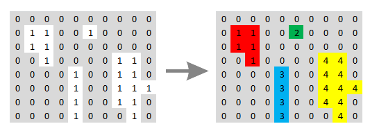
The following diagram shows how distinct regions (with a pixel value of 1) are assigned different labels. The colors are meant for illustration only, to show the different labels assigned to each region.
Example
This example identifies water pixels in a multispectral image and labels each region separately. It uses a color slice classification to color the individual regions.
e = ENVI()
File = Filepath('qb_boulder_msi', Subdir=['data'], $
Root_Dir=e.Root_Dir)
Raster = e.OpenRaster(File)
SubsetTask = ENVITask('SubsetRaster')
SubsetTask.INPUT_RASTER = Raster
SubsetTask.SUB_RECT = [256,253,1023,941]
SubsetTask.Execute
MathTask = ENVITask('PixelwiseBandMathRaster')
MathTask.INPUT_RASTER = SubsetTask.OUTPUT_RASTER
MathTask.EXPRESSION = 'b3 le 180'
MathTask.Execute
FilterTask = ENVITask('BinaryMorphologicalFilter')
FilterTask.INPUT_RASTER = MathTask.OUTPUT_RASTER
FilterTask.METHOD = 'Open'
FilterTask.KERNEL = [[!true,!true,!true], $
[!true,!true,!true], [!true,!true,!true]]
FilterTask.ITERATIONS = 1
FilterTask.Execute
LabelTask = ENVITask('LabelRegions')
LabelTask.INPUT_RASTER = FilterTask.OUTPUT_RASTER
LabelTask.Execute
ColorTask = ENVITask('ColorSliceClassification')
ColorTask.INPUT_RASTER = LabelTask.OUTPUT_RASTER
ColorTask.Execute
DataColl = e.Data
DataColl.Add, ColorTask.OUTPUT_RASTER
View = e.GetView()
Layer = View.CreateLayer(ColorTask.OUTPUT_RASTER)
Syntax
Result = ENVITask('LabelRegions')
Input parameters (Set, Get): INPUT_RASTER, OUTPUT_RASTER_URI
Output parameters (Get only): OUTPUT_RASTER
Parameters marked as "Set" are those that you can set to specific values. You can also retrieve their current values any time. Parameters marked as "Get" are those whose values you can retrieve but not set.
Input Parameters
INPUT_RASTER (required)
Specify a single-band raster.
OUTPUT_RASTER_URI (optional)
Specify a string with the fully qualified filename and path of the associated OUTPUT_RASTER.
- If you do not specify this parameter, or set it to an exclamation symbol (!), ENVI creates a temporary file.
- If you set it to the hash symbol (#), ENVI creates a file in the temporary directory, but this file will not be deleted when ENVI closes.
Output Parameters
OUTPUT_RASTER
This is a reference to the output raster of filetype ENVI.
Methods
Execute
Parameter
ParameterNames
Properties
DESCRIPTION
DISPLAY_NAME
NAME
REVISION
TAGS
Version History
See Also
ENVITask, Masking Support in ENVITasks