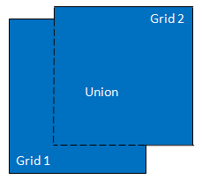
This task regrids a series of rasters to a common spatial grid, using the geometric union of the source rasters. All of the source rasters must be in the same coordinate system. The pixel size of the output series is determined by the first raster in the series.
Example
This example builds a raster series from a collection of Landsat MSS, TM, and -8 images. They are all georeferenced to the same coordinate system, but their sizes and resolution are different. The example uses the geometric union of the source rasters as the basis for reprojecting the other rasters in the series.
This example uses sample images files are available from our ENVI Tutorials web page. Click the Landsat Case Studies link to download the .zip file to your machine, then unzip the files. The files you will use in this example are located in the TimeSeries folder of the download. Update the file references in the example with the correct locations.
e = ENVI()
Files = FILE_SEARCH('C:\Data', 'LasVegas*.dat')
Task = ENVITask('BuildRasterSeries')
numRasters = N_Elements(Files)
rasters = ObjArr(numRasters)
FOR i=0, (numRasters-1) DO $
rasters[i] = e.OpenRaster(Files[i])
Task.INPUT_RASTERS = rasters
Task.Execute
Series = Task.OUTPUT_RASTERSERIES
RegridTask = ENVITask('RegridRasterSeriesByUnion')
RegridTask.INPUT_RASTERSERIES = Series
RegridTask.Execute
DataColl = e.Data
DataColl.Add, RegridTask.OUTPUT_RASTERSERIES
View = e.GetView()
Layer = View.CreateLayer(RegridTask.OUTPUT_RASTERSERIES)
Syntax
Result = ENVITask('RegridRasterSeriesByUnion')
Input parameters (Set, Get): INPUT_RASTERSERIES, OUTPUT_RASTERSERIES_URI, RESAMPLING
Output parameters (Get only): OUTPUT_RASTERSERIES
Parameters marked as "Set" are those that you can set to specific values. You can also retrieve their current values any time. Parameters marked as "Get" are those whose values you can retrieve but not set.
Input Parameters
INPUT_RASTERSERIES (required)
Specify a raster series to reproject.
OUTPUT_RASTERSERIES_URI (optional)
Specify a string with the fully-qualified path and filename for OUTPUT_RASTERSERIES.
RESAMPLING (optional)
Specify the resampling method to use when creating the spatial grid:
- Nearest Neighbor (default): Uses the nearest pixel without any interpolation.
- Bilinear: Performs a linear interpolation using four pixels to resample.
- Cubic Convolution: Uses 16 pixels to approximate the sinc function using cubic polynomials to resample the image.
Output Parameters
OUTPUT_RASTERSERIES
This is a reference to the output raster series.
Methods
Execute
Parameter
ParameterNames
Properties
DESCRIPTION
DISPLAY_NAME
NAME
REVISION
TAGS
Version History
|
ENVI 5.2 |
Introduced |
|
ENVI 5.5 |
Replaced INPUT_RASTERSERIES_URI with INPUT_RASTERSERIES
|
See Also
ENVITask, ENVIGridDefinition, RegridRasterSeries Task, RegridRasterSeriesByIndex Task, RegridRasterSeriesByIntersection Task, BuildRasterSeries Task, BuildTimeSeries Task, ENVIRasterSeries, ENVIRasterSeriesLayer