Modern satellite imagery contains an extensive amount of information; finding specific objects or features within it typically requires large sets of training examples and time-consuming manual work. ENVI Feature Assistant simplifies this process by letting you describe what you are looking for in natural language, without the need to train deep learning models.
Feature Assistant uses two AI models to identify features in remote sensing workflows:
- Grounding DINO is an object detection model that can detect objects based on text prompts. This enables you to search for features such as solar panels, aircraft, shipping containers, and buildings without the need for model training
- Segment Anything 2 (SAM 2) takes the objects that were found by Grounding DINO and traces their exact outlines. Instead of drawing a simple box around an object, it identifies the precise shape of objects and produces feature masks that can be used for measurement, classification, and geospatial analysis.
Using the Feature Assistant Tool, the Grounding DINO and SAM 2 models work together to perform intelligent feature extraction as follows:
- You provide a text prompt that describes the feature to find.
- Grounding DINO scans the image and identifies regions that match your description.
- SAM 2 segments the detected objects to create feature outlines.
- ENVI converts the results into geospatial products, enabling further analysis, visualization, and integration into GIS workflows.
The iterative workflow of the Feature Assistant Tool allows you to set detection parameters, interactively evaluate the results, and refine the search to improve the detection of features within a scene. The Feature Assistant Tool is particularly useful when searching for complex, variable, or visually similar objects that may require multiple parameter adjustments to achieve ideal results.
Feature Assistant uses a local client-server architecture to optimize performance and responsiveness. When you start the Feature Assistant Tool, the AI detection models are loaded and initialized once by the local server process. The ENVI client then communicates directly with the server for detection requests. The models are maintained in memory throughout the session, to provide fast feedback time between feature detections and parameter adjustments.
Note: Grounding DINO and Segment Anything 2 (SAM2) models were trained using RGB-composite data. Feature Assistant will automatically prepare data rasters using the optimal display bands creating a 3-band raster for processing.
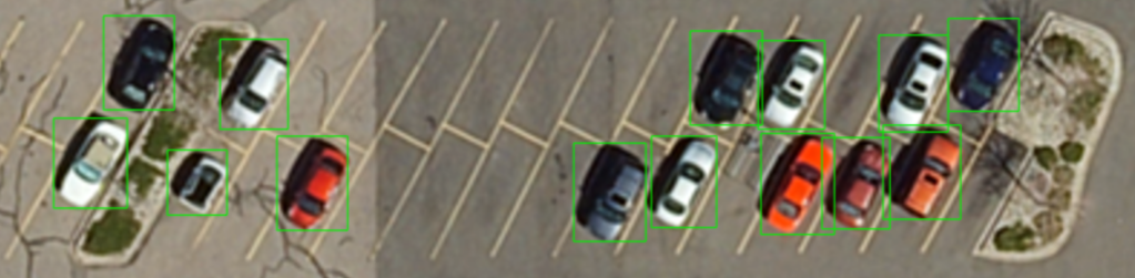
Below is an example detection when using the prompt “vehicles” with the View at 207.5% pixel zoom.
Note: Grounding DINO and Segment Anything 2 (SAM2) models were trained using RGB-composite data. Feature Assistant will automatically prepare data rasters using the optimal display bands creating a 3-band raster for processing.
Raster Processing Background
The quality of feature detection and segmentation results are influenced by the characteristics of the input image data. To achieve the best results with Feature Assistant, it is important to understand raster display settings, image quality, and spatial resolution when identifying features, as described in this section.
Raster Stretch and Brightness
Raster stretch and brightness adjustments can improve or degrade image visualization by enhancing or reducing contrast between features and their surroundings. For best results, display the imagery with sufficient contrast to clearly distinguish target objects from the background.
-
Histogram Stretch increases the visibility of subtle features by expanding the range of displayed pixel values.
-
Brightness and Contrast adjustments can make dark or low-contrast objects easier to identify.
Image Sharpening and Blurring
Image enhancement filters can affect the visibility of features. A moderate level of enhancement provides the best balance between removing noise and preserving key features.
- Sharpening emphasizes edges and fine details, helping small objects such as vehicles, utility structures, or rooftops become more distinguishable.
- Blurring or Smoothing reduces image noise but may also remove fine details that are important for object detection.
- Excessive sharpening can introduce artifacts, while excessive blurring can reduce the effectiveness of feature extraction.
Interpolation Methods
ENVI provides four interpolation options for raster display and navigation. The selected interpolation method affects how the imagery appears when zooming and panning, as well as displaying data at scales other than its native resolution.
- Nearest Neighbor
- Preserves the original pixel values without modification.
- Provides the most accurate representation of source data values.
- Recommended for analytical workflows where maintaining radiometric integrity is important.
- Can appear blocky or pixelated when zoomed in.
- Bilinear
- Calculates pixel values using neighboring pixels to create a smoother display.
- Reduces the blocky appearance commonly seen with Nearest Neighbor.
- Suitable for general image interpretation and visualization.
- Bicubic
- Uses a larger neighborhood of surrounding pixels to create a smoother and more visually appealing image.
- Produces sharper results than Bilinear interpolation while minimizing pixelation.
- Well suited for detailed visual analysis of imagery.
- Optimized Bicubic (Recommended)
- ENVI's default display interpolation method.
- Provides the best balance between image sharpness, smoothness, and feature visibility.
- Enhances the visual appearance of fine details while reducing interpolation artifacts.
- Recommended for identifying and reviewing features in high-resolution imagery when using Feature Assistant.
Interpolation affects the displayed appearance of the imagery but does not change the underlying raster values. For most Feature Assistant workflows, Optimized Bicubic provides the best viewing experience and is recommended for feature detection and segmentation.
Image Quality and Scale Factors
Higher image quality leads to better feature detection performance. Key factors include image sharpness, low noise levels, limited atmospheric distortion, consistent illumination, and sufficient contrast between targets and background. Images that contain compression artifacts, motion blur, haze, excessive shadows, or lower resolutions may reduce detection accuracy.
Spatial Resolution
Spatial resolution determines the amount of ground area represented by each pixel in a raster image. In georeferenced imagery, resolution is typically expressed as the Ground Sample Distance (GSD), such as 0.3 m, 0.5 m, 1 m, or 2 m per pixel. Smaller pixel sizes capture more detail and improve the ability to identify and delineate small features.
The ability to detect an object is related to the number of pixels representing that object. Features occupying only a few pixels may be difficult to distinguish from surrounding imagery, while features represented by dozens of pixels are typically easier to identify and segment accurately.
High-Resolution Imagery
High-resolution imagery contains smaller ground areas per pixel and provides greater visual detail. This is typically the preferred input for Feature Assistant.
Examples include:
|
Resolution (GSD)
|
Typical Feature Visibility
|
|
0.3 m/pixel |
Vehicles, small equipment, utility structures, individual trees
|
|
0.5 m/pixel |
Vehicles, rooftops, road markings, small buildings
|
|
1.0 m/pixel |
Buildings, aircraft, roads, large infrastructure
|
|
2.0 m/pixel+ |
Large facilities, industrial complexes, land cover features
|
Georeferenced vs Pixel Data
Georeferenced Resolution
When imagery contains geographic metadata, ENVI can determine the real-world size of each pixel. The benefits of this are understanding the physical size of detected features and estimating whether target objects are large enough to be reliably identified. Additionally, this can support measurement, mapping, and various GIS workflows, providing consistent results across imagery collected from different sources.
Pixel-Based Resolution
Some imagery may not contain spatial reference information, and resolution is expressed only in image pixels. This means the real-world dimensions of objects are unknown, however, feature detection can still be performed using visual characteristics alone.
Display Scale and Zoom Factor
When spatial resolution information is unavailable, image scale is primarily determined by the display zoom level.
As a general guideline, target features should be clearly visible and occupy a meaningful number of pixels within the image. If an object is difficult for a human analyst to recognize at the native resolution, it will be challenging for automated detection models as well.
Recommended Input Imagery
For best results, use Feature Assistant with the following:
- High-resolution imagery (0.3 m to 1.0 m GSD preferred).
- Georeferenced rasters, when available.
- Sharp, well-focused imagery.
- Minimal cloud cover (unless clouds are the feature), haze, or compression artifacts.
- Sufficient contrast between features and background.
While high-resolution georeferenced imagery is recommended, Feature Assistant can analyze non-georeferenced pixel-based rasters, allowing feature detection and segmentation based solely on image content when geographic metadata is unavailable.
See Also
ENVI Feature Assistant Classification Tutorial, Preference Settings